Astley Village
Appearance
| Astley Village | |
|---|---|
 Astley Village Community Centre (2014) | |
Location within Lancashire | |
| Population | 3,005 (2011 Census) |
| OS grid reference | SD575185 |
| Civil parish |
|
| District | |
| Shire county | |
| Region | |
| Country | England |
| Sovereign state | United Kingdom |
| Post town | CHORLEY |
| Postcode district | PR6, PR7 |
| Dialling code | 01257 |
| Police | Lancashire |
| Fire | Lancashire |
| Ambulance | North West |
| UK Parliament | |
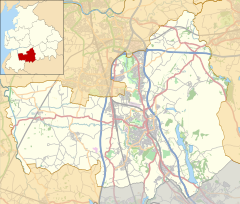
Astley Village is a civil parish in the Borough of Chorley in Lancashire, England, covering a suburb of Chorley. According to the 2011 census, its population was 3,005.[1]
History
[edit]Astley was constructed in the 1970s as a new village. The civil parish was created on 1 April 1991, prior to which the village was divided between the unparished area of Chorley and the parish of Euxton.[2]
Community
[edit]Astley Village is best known for Astley Park, which hosted the Royal Lancashire Show for a number of years.[3][4]
Long Croft Meadow backs onto Chorley Hospital, and the main road through the village is Chancery Road. The village is bypassed via West Way (B5252), a link road opened in 1984 to take traffic off the busy Chancery Road.
References
[edit]- ^ UK Census (2011). "Local Area Report – Astley Village Parish (E04005142)". Nomis. Office for National Statistics. Retrieved 26 March 2021.
- ^ "The Chorley (Parishes) Order 1991" (PDF). LGBCE. 19 February 1991. Retrieved 18 December 2022.
- ^ "All go for Royal Lancs show". lancashiretelegraph.co.uk. 5 July 2002. Retrieved 9 November 2020.
- ^ "Great final show". theboltonnews.co.uk. 9 August 2002. Retrieved 9 November 2020.
External links
[edit]Wikimedia Commons has media related to Astley Village.
- Astley Village chorley.gov.uk


